aisvogel: Maritime Reconnaissance from a Bird’s-Eye View
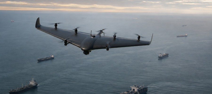

Maritime surveillance faces new challenges: Electronic ship positions can be incomplete or inaccurate. The Karlsruhe-based company hensec secure solutions presents aisvogel, a flying sensor platform that closes this gap. By combining radio, AIS, GNSS, and optical sensor data, the system generates a verified situational picture. The drone acts as a mobile unit that detects anomalies in real time and verifies them autonomously as needed.
A key application of aisvogel is the verification of AIS (Automatic Identification System) data. Since ships automatically transmit their identity, position, and speed, there is a risk of manipulation or spoofing. The platform cross-checks this digital data with independent aerial observations. Camera and infrared sensors confirm physical contact, while spatial inconsistencies or implausible movement patterns are immediately identified. In addition, the system investigates GNSS disruptions such as jamming or spoofing, and the drone itself is equipped with interference-resistant navigation systems.
The technical foundation is the CarryAir system, which combines the advantages of a fixed-wing aircraft with the flexibility of a VTOL (Vertical Take-Off and Landing) system. With a hybrid propulsion system, the platform achieves a flight duration of up to 10 hours. With a wingspan of just under 3 meters, it can carry a payload of 7 kilograms. Six dedicated lift rotors ensure the necessary redundancy for vertical takeoff and landing. Manufacturing takes place entirely in Germany within the European Union.
Cooperative Operation in a Network
The system is particularly effective when operating in a cooperative network. Multiple drones can simultaneously detect signals from different positions. This spatial separation allows suspicious emissions to be precisely pinpointed using direction-finding and geolocation methods. While part of the fleet monitors the area, other units can visually verify targets. This mobile concept replaces costly manned aircraft or helicopters in the surveillance of offshore installations, cable corridors, and sensitive maritime areas.
The aisvogel project marks an important step toward specialized, mission-critical sensor technology. The ability to correlate heterogeneous data sources—from RF signals to optical data—in real time elevates unmanned systems from mere observation platforms to active analysis tools. This is particularly significant for the critical infrastructure (KRITIS) sector.
Furthermore, the system underscores the trend toward swarm intelligence and cooperative operations. The ability to achieve greater measurement accuracy and reliability through a network of multiple platforms opens up new business models for operators, such as in the areas of rental services or continuous monitoring. This development demonstrates that the market increasingly demands solutions that not only fly but also solve complex operational problems through intelligent data fusion.
If you use Google as your search engine, you can set Drones as your preferred source so that our content appears more frequently in your search results. Add Drones as your preferred source.