Wingtra achieves a key accuracy milestone
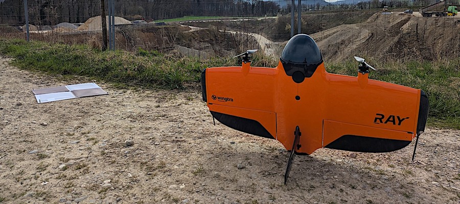

Swiss survey firm Lerch Weber recently conducted an accuracy study comparing Trimble SX10 terrestrial laser scanner (TLS) data to that captured by the WingtraRAY survey drone equipped with its SURVEY61 sensor. The study, published as a case on Wingtra’s website, found the most clear alignment of data accuracy so far when comparing ground-based and drone-acquired survey data.
Specifically, Lerch Weber conducted a survey of a 20 ha (40 ac) gravel pit in Lostorf, Switzerland using both methods. They then ran cross section analysis on four different stockpiles to explore point-to-point variations at each of those cross sections.
“When you look at the data in cross sections like this, it’s just pure data point comparison,” said Juhani Mercuriali, Product Manager at Wingtra, “and what we are seeing is differences so small it shocked us—a difference of 0.24 cubic meters on a 466 cubic meter stockpile. The difference in the volumes that are measured by gold-standard ground survey equipment vs. Wingtra is so small at this point that construction teams can depend on the drone data for similar accuracy.”
Why survey teams should care
While the data in this study was shockingly close, the field cost is exactly the opposite.
“To get a complete data set of a typical gravel pit using terrestrial scanning, it would take a full day, or six to eight hours, due to the need to move around stockpiles and walls to avoid obscured areas,” said Thomas Lerch, Engineering and Geomatics Lead at Lerch Weber. “With Wingtra it took about an hour with field setup included.”
Compared to quadcopters, Lerch said that the setup would take several hours considering the lower flight altitudes, battery changes and planning.
The implications of this are huge: with Wingtra, teams can get surveys done more safely and in a fraction of the time. This removes barriers to getting survey insights more often, which has a ripple effect on planning and contract reconciliation.
Not the first study of this kind; the results show huge progress
Lerch Weber conducted the same study with the eBee drone platform and a TLS in 2018. They published it as research. The study shows accuracy tested with and without ground control points (GCPs) in 2018. GCPs are used to improve the results of the drone data and align them closer to the ground truth. They cost field time to set up.
Even with GCPs, the eBee data of 2018 the point cloud difference was more than twice that of the Wingtra data today. The Wingtra data did not rely on GCPs at all, which is the important field setup differentiator that the company has been eager to promote as part of their latest high-accuracy payload. This study confirms their excitement.
“We are really eager to share these results, because they clearly show that survey teams can get better data, more often with less field time and risk,” Mercuriali said. “This is our constant aim at Wingtra, and it’s really exciting to see it come to life with customers.”
About Wingtra
Wingtra builds a professional aerial surveying and mapping system . Founded in Switzerland in 2017, it developed the only drone solution built specifically for surveyors that covers the entire workflow. From easy flight planning to CAD- and GIS-ready outputs, surveyors walk through guided and connected steps. No more switching tools or guesswork. The result? Survey-grade results in hours—not days. In fact, today, large, renowned companies, government agencies and universities around the world turn to Wingtra for trusted data, no rework, and a more cost-effective way to survey.
Wenn Sie Google als Suchmaschine nutzen, können Sie Drones als bevorzugte Quelle hinterlegen, damit unsere Inhalte häufiger für Sie erscheinen. Fügen Sie Drones als bevorzugte Quelle hinzu.
Im Drones PR-Portal erscheinen Nachrichten und Meldungen von Unternehmen aus der Drone-Economy. Für die Inhalte der Pressemitteilungen sind die jeweiligen Unternehmen verantwortlich.