Wingcopter drones to be deployed for aerial surveying in Japan

Wingcopter’s authorized partner in Japan, ITOCHU Corporation, has signed a Memorandum of Understanding (MOU) to collaborate on the practical use of Wingcopter’s long-range drones in aerial surveying together with PASCO Corporation and YellowScan Japan Co., Ltd.
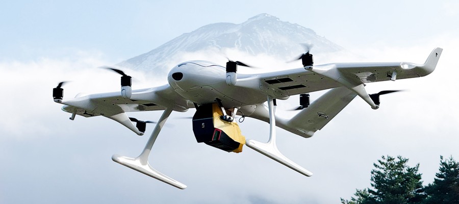
The companies initially plan to use the Wingcopter 198 in disaster management where drone-based surveying is playing an increasingly important role,
1. to create hazard maps and monitor ground deformation as part of effective pre-disaster prevention,
2. to gather information and assess damage in the event of a disaster, and
3. to measure terrain changes and develop recovery plans during post-disaster restoration.
Carrying out these tasks is way easier and less risky with fixed-wing drones such as the Wingcopter 198 than with traditional human or aircraft-based methods, especially as about 70 percent of Japan’s land consists of mountainous and hilly terrain, with steep slopes and short, fast-flowing rivers. Conventional multicopter drones, on the other hand, would not be suitable for such tasks as they are limited in range and coverage compared to the Wingcopter 198.
Under this MOU, YellowScan Japan’s advanced LiDAR scanner „VOYAGER“ will be used on the Wingcopter 198. By integrating this technology with PASCO’s extensive expertise in operational quality and safety in aerial surveying, it is now possible to carry out long-distance and large-area surveys that were previously difficult to achieve without manned aircraft. In a single 45-minute flight, the Wingcopter 198 can scan 1,000+ hectares, simultaneously capturing LiDAR and RGB data, allowing the system to generate an exceptionally high point density and precision. This makes it suitable even for the most demanding applications.
The collaboration also promotes automation and labor savings in surveying tasks, thereby contributing to sustainable development in the surveying industry and reducing disaster risks.
Quotes:
“Japan’s challenging terrain and exposure to natural disasters require the most reliable and advanced surveying technologies available. We are honored to work alongside ITOCHU, PASCO, and YellowScan – all recognized leaders in their respective fields – to combine our expertise and develop the best possible aerial LiDAR solution for this demanding task.”
Steffen Schubkegel, Senior Key Account Manager at Wingcopter
“By equipping the Wingcopter 198 with the industry-leading „VOYAGER“ laser scanner, this collaboration overcomes the range and coverage limitations of traditional multi-copters. This solution is specifically designed to meet Japan’s complex terrain and disaster mitigation requirements. Our goal is to foster innovation that automates surveying workflows and reduces labor requirements, ensuring swifter responses to natural disasters and minimizing associated risks.”
Masaharu Sato, Deputy General Manager, Aerospace Department at ITOCHU Corporation
“Based on PASCO’s more than 70 years of experience and expertise in aerial surveying since its founding, this POC encompassed survey planning, operational design, data acquisition, and evaluation. Going forward, we will continue to work in close collaboration with Wingcopter GmbH and ITOCHU Corporation to address a wide range of societal challenges through the utilization of geospatial information.”
Takashi Shinazawa, Director & Senior Executive Officer Research & Development, Technology Strategy & Intellectual Property at PASCO Corporation
“YellowScan, through its Japanese subsidiary, is pleased to announce this strategic partnership with Wingcopter focused on high-performance systems: the YellowScan Voyager integrated with the Wingcopter 198. This unique combination of a high-end LiDAR solution and a long-range VTOL platform pushes the limits of drone surveying, enabling professionals to map multi-hectare areas in a fraction of the time previously required.
Through such partnerships, YellowScan continues to support professionals worldwide and to drive innovation further.”
Shinji Inaba, General Manager YellowScan Japan
About Wingcopter
Wingcopter is a German drone technology company that develops, manufactures, sells and operates all-electric uncrewed aircraft systems, specializing in enhancing the logistics of urgently needed goods and remote sensing through high-end sensor systems. The 150-strong team is dedicated to improving and saving lives worldwide by building certifiable drone technology for scalable, sustainable and safe operations. Wingcopter is a World Economic Forum Technology Pioneer and Global Innovator.
Thanks to its patented tilt-rotor mechanism and proprietary software algorithms for seamless transition between two flight modes, the Wingcopter 198 can take off and land vertically like a multicopter, while flying long distances as efficiently and quickly as a fixed-wing aircraft, even in harsh weather conditions.
Wingcopter’s investors include Corecam Capital Partners, DRONE FUND, the European Investment Bank, Expa, Futury Capital, Hessen Kapital III, ITOCHU, Nordic Secondary Fund, REWE Group, Salvia, SYNERJET, XAI technologies as well as Xplorer Capital.
Further information: www.wingcopter.com, on LinkedIn and Instagram.
Im Drones PR-Portal erscheinen Nachrichten und Meldungen von Unternehmen aus der Drone-Economy. Für die Inhalte der Pressemitteilungen sind die jeweiligen Unternehmen verantwortlich.